![](/images/other/stat-length.png)
![Trail Walking La Clusaz - La CLUSAZ (Les Confins) - Photo](https://media.geolcdn.com/t/1900/400/ext.pjpeg?maxdim=2&url=https%3A%2F%2Fservices.sitytrail.com%2FGeolivesWS%2FDownloadMedia.ashx%3FTrailID%3D435345%26Media%3Dfix__20150618144710.jpg)
La CLUSAZ (Les Confins)
GerardBouche
User
![Length](/images/other/stat-length.png)
Length
15 km
![Max alt](https://static1.geolcdn.com/siteimages/upload/files/1508320355ic_sort_altitude_max_24dp.png)
Max alt
1419 m
![Uphill gradient](https://static1.geolcdn.com/siteimages/upload/files/1508320355ic_sort_den_pos_24dp.png)
Uphill gradient
624 m
![Km-Effort](/images/other/stat-length.png)
Km-Effort
23 km
![Min alt](https://static1.geolcdn.com/siteimages/upload/files/1508320355ic_sort_altitude_min_24dp.png)
Min alt
1022 m
![Downhill gradient](https://static1.geolcdn.com/siteimages/upload/files/1508320355ic_sort_den_neg_24dp.png)
Downhill gradient
627 m
![Boucle](https://static1.geolcdn.com/siteimages/upload/files/16400158638029165_repeat_loop_refresh_sync_direction_icon.png)
Boucle
Yes
Creation date :
2015-06-29 00:00:00.0
Updated on :
2015-06-29 00:00:00.0
![Walking](https://static1.geolcdn.com/sitytour/trail-icons/101.png)
4h50
Difficulty : Medium
![Scan this QR Code to open this trail in the SityTrail application](https://capi.geolives.com/qq0zvz2zws4bq2lad0pu/sitytour/trails/435345/qr.png?size=200)
FREE GPS app for hiking
About
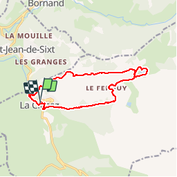
Trail Walking of 15 km to be discovered at Auvergne-Rhône-Alpes, Upper Savoy, La Clusaz. This trail is proposed by GerardBouche.
Description
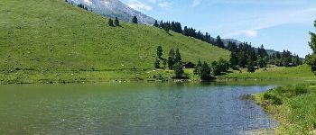
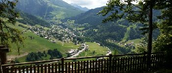
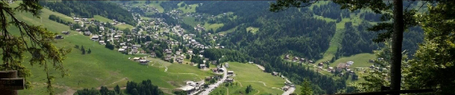
Superbe rando vers le lac des Confins par le bois de la Motte ... tour du lac et restauration au "Chalet ". Retour par les Frasses, les Mouilles de la Perrière et le pt de vue du Belvédère.
Positioning
Country:
France
Region :
Auvergne-Rhône-Alpes
Department/Province :
Upper Savoy
Municipality :
La Clusaz
Location:
Unknown
Start:(Dec)
Start:(UTM)
300241 ; 5086821 (32T) N.
Comments
Trails nearby
![Trail Snowshoes Manigod - croix de colonban croix de fry - Photo](https://media.geolcdn.com/t/375/260/ext.jpg?maxdim=2&url=https%3A%2F%2Fservices.sitytrail.com%2FGeolivesWS%2FDownloadMedia.ashx%3FTrailID%3D926852%26Media%3Dfix__20180316164408.jpg)
![Snowshoes Snowshoes](https://static1.geolcdn.com/sitytour/trail-icons/504.png)
croix de colonban croix de fry
Snowshoes
Medium
(3)
Manigod,
Auvergne-Rhône-Alpes,
Upper Savoy,
France
![](/images/other/stat-length.png)
8 km | 11.6 km-effort
3h 5min
![](https://static1.geolcdn.com/siteimages/upload/files/16400158638029165_repeat_loop_refresh_sync_direction_icon.png)
Yes
![Trail Mountain bike Le Grand-Bornand - vtt-dans-la-vallee-du-bouchet - Photo](https://media.geolcdn.com/t/375/260/ext.jpg?maxdim=2&url=https%3A%2F%2Fmedia.geolcdn.com%2Ff%2F54ff3393-bd57-478d-bb91-ac4f8bbf5514.JPG)
![Mountain bike Mountain bike](https://static1.geolcdn.com/sitytour/trail-icons/202.png)
vtt-dans-la-vallee-du-bouchet
Mountain bike
Very easy
Le Grand-Bornand,
Auvergne-Rhône-Alpes,
Upper Savoy,
France
![](/images/other/stat-length.png)
7.5 km | 10.5 km-effort
Unknown
![](https://static1.geolcdn.com/siteimages/upload/files/16400158638029165_repeat_loop_refresh_sync_direction_icon.png)
No
![Trail Mountain bike Le Grand-Bornand - VTT du grand bornand au refuge - Photo](https://media.geolcdn.com/t/375/260/ext.jpg?maxdim=2&url=https%3A%2F%2Fmedia.geolcdn.com%2Ff%2F6e7f1cd1-a092-45d8-ad55-e241b31fcd09.JPG)
![Mountain bike Mountain bike](https://static1.geolcdn.com/sitytour/trail-icons/202.png)
VTT du grand bornand au refuge
Mountain bike
Very easy
Le Grand-Bornand,
Auvergne-Rhône-Alpes,
Upper Savoy,
France
![](/images/other/stat-length.png)
25 km | 38 km-effort
Unknown
![](https://static1.geolcdn.com/siteimages/upload/files/16400158638029165_repeat_loop_refresh_sync_direction_icon.png)
Yes
![Trail Mountain bike Le Grand-Bornand - Le_Grand_Bornand_20210706_104522 - Photo](https://media.geolcdn.com/t/375/260/ext.jpg?maxdim=2&url=https%3A%2F%2Fmedia.geolcdn.com%2Ff%2Fc69ac290-aa7a-435a-b347-3adb99de2083.JPG)
![Mountain bike Mountain bike](https://static1.geolcdn.com/sitytour/trail-icons/202.png)
Le_Grand_Bornand_20210706_104522
Mountain bike
Very easy
Le Grand-Bornand,
Auvergne-Rhône-Alpes,
Upper Savoy,
France
![](/images/other/stat-length.png)
18.4 km | 29 km-effort
Unknown
![](https://static1.geolcdn.com/siteimages/upload/files/16400158638029165_repeat_loop_refresh_sync_direction_icon.png)
Yes
![Trail Walking La Clusaz - Les Converses, Le Planet, Beauregard, les Corbassières (boucle) - Photo](https://media.geolcdn.com/t/375/260/ext.jpg?maxdim=2&url=https%3A%2F%2Fmedia.geolcdn.com%2Ff%2Ffc969c4d-6540-4dae-ad1a-e21a9acad593.jpg)
![Walking Walking](https://static1.geolcdn.com/sitytour/trail-icons/101.png)
Les Converses, Le Planet, Beauregard, les Corbassières (boucle)
Walking
Difficult
La Clusaz,
Auvergne-Rhône-Alpes,
Upper Savoy,
France
![](/images/other/stat-length.png)
10.4 km | 17.7 km-effort
3h 11min
![](https://static1.geolcdn.com/siteimages/upload/files/16400158638029165_repeat_loop_refresh_sync_direction_icon.png)
Yes
![Trail Mountain bike Le Grand-Bornand - Le_Grand_Bornand_20200623_090207 - Photo](https://media.geolcdn.com/t/375/260/ext.jpg?maxdim=2&url=https%3A%2F%2Fmedia.geolcdn.com%2Ff%2Fb158b8f9-4e2e-4854-b818-a288cc3cda0b.JPG)
![Mountain bike Mountain bike](https://static1.geolcdn.com/sitytour/trail-icons/202.png)
Le_Grand_Bornand_20200623_090207
Mountain bike
Very easy
Le Grand-Bornand,
Auvergne-Rhône-Alpes,
Upper Savoy,
France
![](/images/other/stat-length.png)
26 km | 38 km-effort
Unknown
![](https://static1.geolcdn.com/siteimages/upload/files/16400158638029165_repeat_loop_refresh_sync_direction_icon.png)
No
![Trail Snowshoes La Clusaz - col aravis - Photo](https://media.geolcdn.com/t/375/260/ext.jpg?maxdim=2&url=https%3A%2F%2Fservices.sitytrail.com%2FGeolivesWS%2FDownloadMedia.ashx%3FTrailID%3D926860%26Media%3Dfix__20180314155607.jpg)
![Snowshoes Snowshoes](https://static1.geolcdn.com/sitytour/trail-icons/504.png)
col aravis
Snowshoes
Easy
(2)
La Clusaz,
Auvergne-Rhône-Alpes,
Upper Savoy,
France
![](/images/other/stat-length.png)
5.7 km | 8.2 km-effort
2h 16min
![](https://static1.geolcdn.com/siteimages/upload/files/16400158638029165_repeat_loop_refresh_sync_direction_icon.png)
Yes
![Trail Walking La Clusaz - confins - Trou de la mouche - Photo](https://media.geolcdn.com/t/375/260/ext.jpg?maxdim=2&url=https%3A%2F%2Fservices.sitytrail.com%2FGeolivesWS%2FDownloadMedia.ashx%3FTrailID%3D649324%26Media%3De8817909-efba-47ef-85a6-4fb05f5f6537.JPG)
![Walking Walking](https://static1.geolcdn.com/sitytour/trail-icons/101.png)
confins - Trou de la mouche
Walking
Medium
(1)
La Clusaz,
Auvergne-Rhône-Alpes,
Upper Savoy,
France
![](/images/other/stat-length.png)
9.5 km | 23 km-effort
4h 38min
![](https://static1.geolcdn.com/siteimages/upload/files/16400158638029165_repeat_loop_refresh_sync_direction_icon.png)
Yes
![Trail Mountain bike La Clusaz - VTT Aravis - Photo](https://media.geolcdn.com/t/375/260/ext.jpg?maxdim=2&url=https%3A%2F%2Fstatic1.geolcdn.com%2Fsiteimages%2Fupload%2Ffiles%2F1524743154velo.jpg)
![Mountain bike Mountain bike](https://static1.geolcdn.com/sitytour/trail-icons/202.png)
VTT Aravis
Mountain bike
Medium
(1)
La Clusaz,
Auvergne-Rhône-Alpes,
Upper Savoy,
France
![](/images/other/stat-length.png)
35 km | 52 km-effort
2h 38min
![](https://static1.geolcdn.com/siteimages/upload/files/16400158638029165_repeat_loop_refresh_sync_direction_icon.png)
Yes